USGS Nebraska Water Science Center
Science Themes
Streamflow, Groundwater, and Lakes
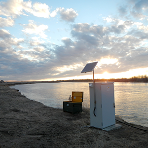
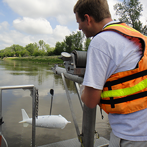
Continuous and discrete surface-water, groundwater, and water-quality data are collected to provide long-term hydrologic records critical to investigating hydrology, modeling climate-change, evaluating natural and anthropogenic changes in the hydrologic regime, and providing information on water availability to water managers.
- Explore Our Data
- Real-Time Sites: Interactive map of real-time data collection sites
- Surface Water: Current conditions, historical observations, daily data, statistics, and peak streamflow data
- Groundwater: Current conditions, historical observations, daily data, and statistics
- Water Quality: Current conditions, historical observations, daily data, and statistics
- Water Use: State data
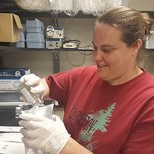
Water Quality
Information about water quality in streams and rivers throughout Nebraska is critical to making informed decisions about water resources. Data can be collected from rivers and streams, analyzed, then used by water managers for making decisions to improve water quality. Our research focuses on
- ensuring water used for consumption meets drinking water standards;
- monitoring of nitrates, pesticides, bacteria, sediment, other pollutants, and water-quality parameters;
- providing instantaneous results, such as those available on the Platte River, to the public through NWISweb;
- monitoring of aquatic systems and habitats for ecological changes.
- Current Research
- Groundwater
- Groundwater Quality and Age of Secondary Bedrock Aquifers, Eastern Nebraska
- Papio-Missouri River Natural Resources District Groundwater Quality Monitoring
- Groundwater-Quality Monitoring near Ashland, Nebraska
- Surface Water
- Improving the Water Quality of Cub Creek: Homestead National Monument Water Quality Partnership
- Missouri River Water-Quality Monitoring in Relation to Combined Sewer Overflow Systems near Omaha, Nebraska
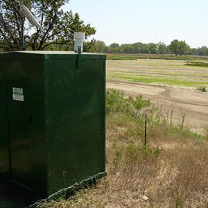
- Continuous Water-Quality Monitoring Network
- Nutrients and Productivity in the Lower Niobrara-Middle Missouri Confluence Area and the 59-mile reach of Missouri River between Gavins Point Dam and Ponca State Park
- Bioretention Cell Monitoring
- Understanding Cyanobacteria Blooms in the Willow Creek Reservoir
- Missouri River Recovery—Chute Construction Monitoring
Water Availability and Use
How much water is available and how water resources are used are critical questions for managers of Nebraska's water resources. USGS scientists use models to simulate how water use may affect water resources, study the interaction between groundwater and surface water, and monitor water levels throughout the state. Our research focuses on
- examining the interaction between surface water and groundwater;
- improving understanding of aquifer responses to continuing demands on groundwater resources;
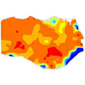
- estimating water-level and storage changes in large aquifers such as the High Plains aquifer;
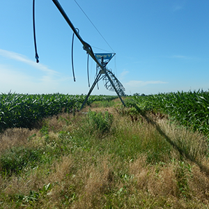
- investigating novel mechanisms affecting streamflow such as tile drains;
- determining which aquifers are a usable resource using age tracers and water-quality data;
- providing new insights into water budgets by estimating quantities of groundwater recharge and stream base flow and relating them to soil type, land use, and geology on local scales; and
- measuring and evaluating the movement of recharge water through the unsaturated zone.
- Current Research
- Groundwater
- Groundwater/surface-water interaction near the confluence of the Elkhorn and Lower Platte Rivers
- High Plains Groundwater Availability Study
- High Plains Water-Level Monitoring Study
- Groundwater Quality and Age of Secondary Bedrock Aquifers, Eastern Nebraska
- Sand Hills and Dissected Plains Water Budgets
- Water Movement Through the Unsaturated Zone of the High Plains Aquifer in the Central Platte Natural Resources District, Nebraska
- Surface Water
- Delineation of Areas Potentially Drained by Tile Drains and Updating of Streamflow-Trend Statistics from the Elkhorn River Basin in Eastern Nebraska
Floods and Drought
Natural hazards, such as floods and droughts, can have long-term impacts on communities. By mapping the extent of floods and studying how water managers can best manage water resources, the USGS Nebraska Water Science Center is helping mitigate the effects of natural hazards. Our research focuses on
- Increasing understanding about the sustainability of water resources during prolonged drought, and
- Estimating extents of flood waters using the USGS Flood Inundation Mapping process.
Advanced Technologies and Modeling
USGS Nebraska Water Science Center scientists have extensive modelling expertise and experience including advanced regional and local numerical groundwater models which run on an extensive computer array; multi-dimensional and steady and unsteady flow models; flood inundation maps and flood insurance studies; empirical and theoretical run-off models; and innovative and complex numerical optimization and parameter estimation techniques. These simulations can identify risks both to water resources and infrastructure and can also develop management scenarios to minimize those risks. Our research focuses on
- developing information and tools that can be used to assess the groundwater availability of the northern High Plains aquifer;
- evaluating regional and temporal trends in the mass balance of groundwater resources for entire aquifers and quantifying the natural and anthropogenic processes that affect water budgets;
- modeling effects of groundwater withdrawal on the availability of surface water and the long-term effects of groundwater withdrawal on the groundwater resource;
- estimating quantities of groundwater recharge and stream base flow and relating them to soil type, land use, and geology on a local scale; and
- using thermal imagery and coupled groundwater/surface-water gages to understand groundwater/surface-water interaction.
- Current Research
- Modeling
- High Plains Groundwater Availability Study
- Elkhorn Loup Model
- Sand Hills and Dissected Plains Water Budgets
- Groundwater/Surface-Water Interactions in the Loup River Basin
- Advanced Technologies
- Flood Inundation Mapping
- Water Movement Through the Unsaturated Zone of the High Plains Aquifer in the Central Platte Natural Resources District, Nebraska
Ecological Monitoring
USGS scientists are researching how stream ecology responds to changing conditions such as climate, chemical stressors, and habitat changes across a variety of ecosystems in Nebraska. Our research focuses on
- understanding process that create and maintain ecological habit;
- monitoring and assessing geomorphic change and sediment transport in river side-channels and chutes;
- determining why aquatic productivity within river reaches may be low and the researching the effects of low productivity on fish health;
- investigating possible causes and characteristics of algal blooms;
- monitoring the effectiveness of bioretention cells as a method of stormwater management; and
- exploring variation and usability of sand bars as habitat.
- Current Research
- Surveying and Monitoring Constructed Chutes on the Missouri River
- Nutrients and Productivity in the Lower Niobrara-Middle Missouri Confluence Area and the 59-mile reach of Missouri River between Gavins Point Dam and Ponca State Park
- Bioretention Cell Monitoring, Douglas County, Nebraska
- Understanding Cyanobacteria Blooms in the Willow Creek Reservoir
- Bioretention Cell Monitoring, Omaha Sewer Maintenance Facility
- Understanding Sandbar Dynamics in the Lower Platte River
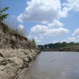
Sediment
USGS scientists are researching the effectiveness of aquatic habitat restoration and the impacts of flow management/augmentation on the shape of stream channels. Our research focuses on
- monitoring and assessing geomorphic change and sediment transport in constructed river side-channels and chutes;
- determining whether sand from reservoir deltas can be used as proppant; and
- assessing the impact of hydraulic dredging discharge.