High Plains Water-Level Monitoring Study (Groundwater Resources Program)
High Plains Water-Level Monitoring StudyThe High Plains Water-Level Monitoring Study (HPWLMS) is the USGS's response to a directive from Congress to report on water-level changes in the High Plains [Ogallala] aquifer (figure 1). 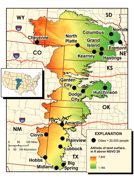 Figure 1. Location map showing the boundary of the High Plains aquifer, major cities and roads, and altitude of land surface. .")
The directive from Congress was contained in the Water Resources Development Act of 1986 (Public Law 99-662). This law recognized the economic importance of the High Plains aquifer to the States in the High Plains region and added Title III to the Water Resources Research Act of 1984 (Public Law 98-242). Title III states that the USGS in cooperation with "...the States of the High Plains region is authorized and directed to monitor the levels of the Ogallala [High Plains] Aquifer, and report annually to Congress." The original directive was modified by the Federal Reports Elimination and Sunset Act of 1995 (Public Law 104-66). In this legislation, Congress directed the USGS to report on water-level changes in the Ogallala [High Plains] aquifer every two years instead of annually. The objectives of the HPWLMS are:
New publication brief
Information on the High Plains AquiferSummary Statistics from Past USGS Reports - 1987 to 2013
|

![]() U.S. Department of the Interior |
U.S. Geological Survey
U.S. Department of the Interior |
U.S. Geological Survey
URL: http://ne.water.usgs.gov/ogw/hpwlms/index.html
Page Contact Information: GS-W-NE_Webmaster
Page Last Modified: Monday, 22-Dec-2014 10:11:19 EST