HIGH PLAINS WATER-
LEVEL MONITORING STUDY
[an error occurred while processing this directive]
ASSOCIATED USGS OFFICES
AND PROGRAM
|
Publications

Reports for the High Plains Water-Level Monitoring Study (HPWLMS) were generated annually from 1988 to 1995 and generally every two years from 1997 to 2009 to report water-level changes in the High Plains aquifer from predevelopment to the reporting year. For 2000, a special type of USGS report, a Circular, was generated to present information for the general public on changes in water in storage from predevelopment (about 1950) to 2000 and on groundwater management approaches used by the States in the High Plains region.
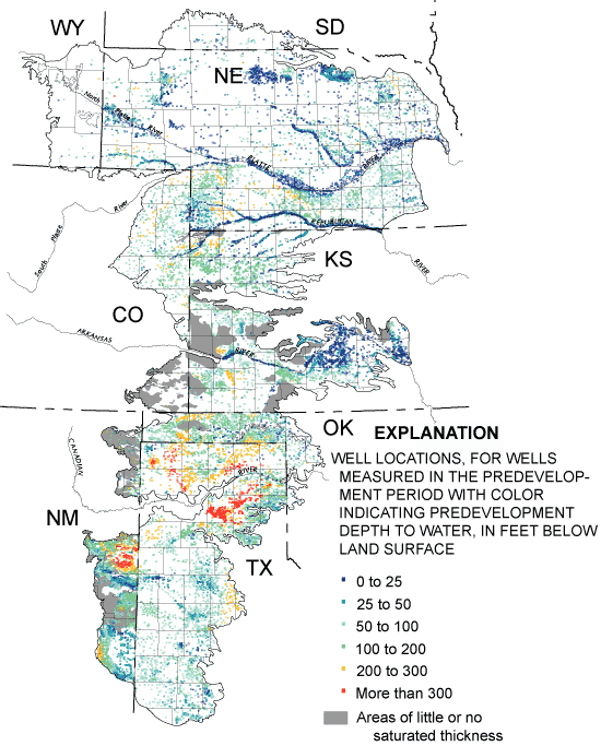
 Figure 12. Well locations and depth to water in the predevelopment period for wells screened in the High Plains aquifer. (Click image for larger version). The "predevelopment" water level in the aquifer is defined as the water level in the aquifer before extensive groundwater pumping for irrigation, or about 1950. The predevelopment water level was generally estimated by using the earliest water-level measurement in more than 20,000 wells (figure 12) (McGuire and others, 2003). Depths to water in the predevelopment period ranged from land surface to more than 300 feet below land surface.
In the 1988 to 1999 reports, the maps of long-term water-level changes were for the period spring 1980 to spring of the report year. In these reports, the change in water in storage from predevelopment to the report year is calculated by using a map of water-level changes, predevelopment to 1980 (Gutentag and others, 1984), with the report's map of water-level changes, 1980 to the report year.
In the 2000 to 2013 reports, the map of long-term water-level changes is for the period predevelopment to spring of the report year. In these reports, the change in water in storage is calculated directly from the report's maps of water-level changes. In 2002, an extra HPWLMS report was generated with maps of water-level changes from spring 1980 to spring 2002. A network of 8,613 wells was used to monitor water levels in the High Plains aquifer in 2013 (McGuire, 2014).
High Plains Water-Level Monitoring Study Publications
2013 publication brief
2013 report and digital data file
2011 report and digital data file
2009 reports
- McGuire, V.L., 2011, Water-Level Changes in the High Plains Aquifer, Predevelopment to 2009, 2007-08, and 2008-09 and Change in Water in Storage, Predevelopment to 2009: U.S. Geological Survey Scientific Investigations Report 2011-5089
- McGuire, V.L., 2011, Changes in Water Levels and Storage in the High Plains Aquifer, Predevelopment to 2009: U.S. Geological Survey Fact Sheet FS-2011-3069
2007 reports and digital data file
- McGuire, V.L., 2009, Water-Level Changes in the High Plains Aquifer, Predevelopment to 2007, 2005-06, and 2006-07: U.S. Geological Survey Scientific Investigations Report 2009-5019
- McGuire, V.L., 2009, Changes in Water Levels and Storage in the High Plains Aquifer, Predevelopment to 2007: U.S. Geological Survey Fact Sheet FS-2009-3005
2005 reports
2003 report
2002 report
2001 report
2000 report
- McGuire, V.L., Johnson, M.R., Schieffer, R.L., Stanton, J.S., Sebree, S.K., and Verstraeten,
I.M., 2003, Water in storage and approaches to ground-water management, High Plains aquifer, 2000: U.S. Geological Survey Circular 1243
1999 report
1998 Web page
1997 report and digital data files
- Fischer, B.C., Kollasch, K.M., McGuire, V.L., 2000, Digital map of saturated thickness in the
High Plains Aquifer in parts of Colorado, Kansas, Nebraska, New Mexico, Oklahoma, South Dakota,
Texas, and Wyoming, 1996 to 1997: U.S. Geological Survey Open-File Report 2000-300
- Fischer, B. C.; Kollasch, K. M.; McGuire, V. L., 2000, Digital map of water-level changes in the High Plains Aquifer in parts of Colorado, Kansas, Nebraska, New Mexico, Oklahoma, South Dakota, Texas, and Wyoming, 1980 to 1997: U.S. Geological Survey Open-File Report 2000-96
- McGuire, V.L., and Fischer, B.C., 1999, Water-level changes, 1980 to 1997, and saturated
thickness, 1996-97, in the High Plains aquifer: U.S. Geological Survey Fact Sheet 124-99
1996 Web page and digital data file
- Fischer, B.C., McGuire, V.L., 1999, Digital data set of water-level changes in the High
Plains aquifer in parts of Colorado, Kansas, Nebraska, New Mexico, Oklahoma, South Dakota, Texas, and Wyoming, 1980 to 1996: U.S. Geological Survey Open-File Report 99-198
- McGuire, V.L., Stanton, C.P., and Fischer, B.C., Water-level changes in High Plains aquifer, 1980-96: U.S. Geological Survey data
1995 report and digital data file
- Fischer, B.C., McGuire, V.L., 1999, Digital data set of water-level changes in the High Plains aquifer in parts of Colorado, Kansas, Nebraska, New Mexico, Oklahoma, South Dakota, Texas, and Wyoming, 1980 to 1995: U.S. Geological Survey Open-File Report 99-197
- McGuire, V.L., and Sharpe, J.B., 1997, Water-level changes in High Plains aquifer-predevelopment
to 1995: U.S. Geological Survey Water-Resources Investigations Report 97-4081
- McGuire, V.L., and Sharpe, J.B., 1997, Water-level changes in High Plains aquifer, 1980 to 1995: U.S. Geological Survey Fact Sheet 068-97
1994 reports
- Dugan, J.T., and Sharpe, J.B., 1996, Water-Level Changes in the High Plains aquifer,
Predevelopment to 1994: U.S. Geological Survey Water-Resources Investigations Report 95-4208
- Dugan, J.T., and Sharpe, J.B., 1996, Water-Level Changes in the High Plains Aquifer, 1980 to 1994: U.S. Geological Survey Fact Sheet 215-95
1993 report
1992 report
1991 report
1990 report
1989 report
- Dugan, J.T., Schild, D.E., and Kastner, W.M., 1990, Water-level changes in the High Plains aquifer underlying parts of South Dakota, Wyoming, Nebraska, Colorado, Kansas, New Mexico,
Oklahoma, and Texas-Predevelopment through nonirrigation season 1988-89: U.S. Geological
Survey Water-Resources Investigations Report 90-4153
1988 report
- Kastner, W.M., Schild, D.E., and Spahr, D.S., 1989, Water-level changes in the High Plains aquifer underlying parts of South Dakota, Wyoming, Nebraska, Colorado, Kansas, New Mexico,
Oklahoma, and Texas-Predevelopment through nonirrigation season 1987-1988: U.S. Geological
Survey Water-Resources Investigations Report 89-4073
|