Groundwater/Surface-Water Interactions in the Loup River Basin
Streams in the Loup River basin are sensitive to groundwater withdrawals because of the close hydrologic connection between groundwater and surface water. Pumping from aquifers that are hydrologically connected to surface-water bodies can have a significant effect on the streams by reducing the groundwater discharge to surface water. An evaluation of any groundwater management strategy needs to involve consideration of the impact on surface-water resources. Four stream reaches, totaling approximately 320 river miles, have been identified by the Upper and Lower Loup Natural Resources Districts as priority streams where additional groundwater/surface-water interaction information is needed to properly manage their water resources. The USGS, in cooperation with the Upper and Lower Loup Natural Resources Districts, received a grant from the Nebraska Environmental Trust to study and address these water supply concerns.
Goals of this Study
This study is focused on investigating and describing the spatial and temporal characteristics of groundwater/surface-water interaction for selected stream reaches in the Loup River basin. Specific goals are:
- Create maps of focused and diffuse groundwater discharge zones within selected reaches in the Loup River basin. Temperature anomalies identified from airborne thermal infrared imagery will be ground-truthed with several ground-based methods including streamflow, water temperature, and potentiomanometer measurements.
- Identify zones of focused and diffuse groundwater discharge and evaluate spatial trends across various physical and geologic settings in the Loup River basin with interpreted airborne thermal infrared data.
- Establish four additional coupled groundwater/surface-water gaging stations at established streamflow gaging stations by installing streambank observation wells instrumented with water-level and water-temperature recorders. All continuous water-level and water-temperature data collected will be stored in the publicly accessible USGS National Water Information System (NWIS) and served real time on the internet from NWISweb.
- Analyze data from a network of coupled groundwater/surface-water gages with unique land-use characteristics to help determine the effects of seasonal climate and irrigation practices on groundwater/surface-water interaction. Data collected from these gages can indicate whether a stream is gaining or losing near the gaging location and will improve the understanding of the seasonal climate and irrigation practices on groundwater/surface-water interaction at each coupled groundwater/surface-water gaging station.
Imagery
Over these reaches, airborne thermal infrared imagery will be collected and used to map stream surface temperatures to identify thermal anomalies, which may be indicative of focused groundwater discharge. Airborne thermal data will be verified with continuous water-temperature data from stream-gaging stations and from self-logging thermistors. Mapped thermal anomalies will be investigated with a variety of techniques including water temperature, potentiomanometer, and seepage meter measurements.
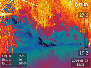
Thermal image of focused groundwater discharge on the South Loup River.
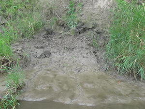
Groundwater seep on the bank of the South Loup River.