The Platte River Program A USGS Priority Ecosystems Program
The Platte River Program—Managed ReachBack to Cottonwood Ranch main page
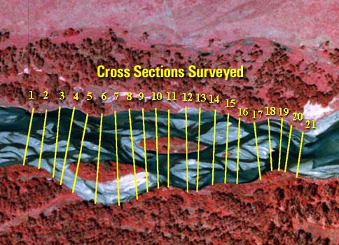
Other available topographic survey and bed sediment data: Input | Output Index of Cross-Sectional DataCross sections numbered upstream to downstream and are resurveyed periodically. Text files for each cross section include distance from left pin (m) and elevation (m).
Index of Bed Sediment DataSampling stations are along the cross sections at equal intervals and are numbered from right bank. Text files for corresponding cross section or bank with sample station and sediment parameters.
Index of Bank Sediment DataSediment samples taken from top of bank to edge of water within each distinctive stratigraphic layer.
Disclaimer: Please note that some U.S. Geological Survey (USGS) information accessed through this page may be preliminary in nature and presented prior to final review and approval by the Director of the USGS. This information is provided with the understanding that it is not guaranteed to be correct or complete and conclusions drawn from such information are the sole responsibility of the user. Any use of trade, product, or firm names in this publication is for descriptive purposes only and does not imply endorsement by the U.S. Government. For information regarding the Cottonwood Ranch Project please contact: Paul J Kinzel--pjkinzel@usgs.gov | ||||||||||||||||||||||||||||||||||||||||||||||||||||||||||||||||||||||||||||||||||||||||||||||||||||||||||||||||||||||||||||||||||||||||||||||||||||||||||||||||||||||||||||||||||||||||||||||||||||||||||||||||||||||||||||||||||||||||||||||||||||||||||||||||||||||||||||||||||||||||||||||||||||||||||||||||||||||||||||||||||||||||||||||||

![]() U.S. Department of the Interior |
U.S. Geological Survey
U.S. Department of the Interior |
U.S. Geological Survey
URL: http://ne.water.usgs.gov/platte/cottonwood/managed/index.html
Page Contact Information: GS-W-NE_Webmaster
Page Last Modified: Tuesday, 04-Feb-2014 12:26:45 EST