Why Study Brackish Groundwater?
Sources of Dissolved Solids in Brackish Groundwater
How is Brackish Groundwater Being Used?


Previous Work
A national compilation of data on mineralized (brackish) groundwater was completed in the 1960s (Feth and others, 1965). That study provided maps showing depth to the shallowest groundwater containing more than 1,000 mg/L of dissolved solids and chemical types of groundwater, serving as the primary source of information for subsequent assessments of the national distribution of brackish groundwater. Feth (1965b) also compiled a reference list of approximately 500 reports documenting saline groundwater conditions that "is by no means exhaustive, but it is representative of the types of information available and will serve to lead the reader into the literature." In addition, Feth (1981) and Richter and Kreitler (1991) summarized various models and mechanisms used to explain the spatial and temporal variability of dissolved solids in groundwater. Feth (1981) provided a national synthesis of chloride in natural waters, noting that the ratio of various other anions to chloride can be used to identify the source of brackish groundwater. Richter and Kreitler (1991) supplemented work by Feth and others (1965) with a map by Dunrud and Nevins (1981) showing the approximate extent of halite (sodium chloride salt) deposits, mapped locations of oil fields, estimates of the extent of seawater intrusion to coastal aquifers, and mapped saline springs and seeps to identify areas where brackish groundwater naturally occurs. Richter and Kreitler (1991) also provided a state-by-state summary of the occurrence of each source of groundwater salinization.
USGS Regional Aquifer-System Analysis (RASA) studies were conducted between 1978 and 1995 to define the regional geohydrology of the Nation's important aquifer systems. Maps showing dissolved-solids concentrations were published for many of these aquifer systems and compiled for the USGS Ground Water Atlas of the United States (U.S. Geological Survey, 2000). In some cases, regional RASA studies included geochemical characterization and modeling, which assisted with understanding, interpolating, and extrapolating brackish water occurrence (for example, Busby and others, 1995).

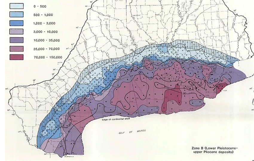
Total dissolved-solids concentration, in milligrams per liter
(Source: Pettijohn and others, 1988; Gulf Coastal Plain RASA Study)
More recently, Androwski and others (2011) used previously published USGS reports to conduct a national assessment of the total volume of the saline (dissolved-solids concentration between 1,000 and 35,000 mg/L) component of the principal aquifers of the conterminous United States that could be available for desalination. The primary sources of dissolved-solids and aquifer-dimension information for that study were digital maps from the USGS Ground Water Atlas of the United States (U.S. Geological Survey, 2000). No recently collected dissolved-solids data were used for the study, and depths to saline groundwater were estimated using simplistic assumptions and methods.
Examples of several regional assessments of brackish aquifers:
- The USGS, through the Groundwater Resources Program, is completing three pilot studies that use geochemical, geophysical, and geostatistical methods and previously published work to describe saline aquifers for the southern midcontinent, Mississippi embayment, and the southeastern United States. These "Challenge Area" studies were conducted from 2010 through 2012 to supplement the Groundwater Resources Program's freshwater regional groundwater availability assessments already underway in order to achieve a more complete picture of the Nation's groundwater availability.
- Sandia National Laboratories is assessing the relative availability and cost of using shallow (less than 2,500 feet (ft) below land surface) brackish groundwater as a water source for thermoelectric power generation in 17 western states (Vince Tidwell, Sandia National Laboratories, written commun., 2013). Sources of information for estimating the availability of brackish groundwater include volumetric estimates of brackish groundwater in Texas and Arizona, USGS water use information (Kenny and others, 2009), and data for wells in the USGS National Water Information System (NWIS) that contain brackish groundwater.
- The Texas Water Development board is conducting the Brackish Resources Aquifer Characterization System (BRACS) study to provide a detailed characterization of brackish aquifers in Texas using geophysical bore-hole logs and available aquifer data (Meyer and others, 2011).
Selected References
Androwski, James, Springer, Abraham, Acker, Thomas, and Manone, Mark, 2011, Wind-Powered Desalination: An Estimate of Saline Groundwater in the United States: Journal of the American Water Resources Association, v. 47, no. 1, p. 93-102.
Busby, J.F., Kimball, B.A., Downey, J.S., and Peter, K.D., 1995, Geochemistry of water in aquifers and confining units of the Northern Great Plains in parts of Montana, North Dakota, South Dakota, and Wyoming: U.S. Geological Survey Professional Paper 1402-F, 146 p.
Dunrud, C.R., and Nevins, B.B., 1981, Solution mining and subsidence in evaporite rocks in the United States: U.S. Geological Survey Miscellaneous Investigations Series Map 1298, scale 1:5,000,000.
Feth, J. H., and others, 1965, Preliminary map of the conterminous United States showing depth to and quality of shallowest ground water containing more than 1,000 parts per million dissolved solids: U.S. Geological Survey Hydrologic Investigations Atlas, HA-199, 31 p., 2 plates, scale 1:3,000,000.
Feth, J. H., 1965b, Selected references on saline ground-water resources of the United States; U.S. Geological Survey Circular 499, 30 p.
Feth, J. H., 1981, Chloride in Natural Continental Water-A Review: U.S. Geological Survey Water-Supply Paper 2176, 30 p.
Kenny, J.F., Barber, N.L., Hutson, S.S., Linsey, K.S., Lovelace, J.K., and Maupin, M.A., 2009, Estimated use of water in the United States in 2005: U.S. Geological Survey Circular 1344, 52 p.
Meyer, J.E., Wise, M.R., Kalaswad, Sanjeev, 2011, Pecos Valley Aquifer, West Texas—Structure and Brackish Groundwater: Texas Water Development Board Report, 85 p. (PDF)
Pettijohn, R.A., Weiss, J.S. Williamson, A.K., 1988, Distribution of dissolved-solids concentrations and temperature in ground water of the gulf coast aquifer systems, south-central United States: U.S. Geological Survey Water-Resources Investigations Report 88-4082, 5 plates, scale 1:3,500,000.
Richter, B.C., and Kreitler, C.W., 1993, Identification of sources of groundwater salinization using geochemical techniques: Ada, Okla., U.S. Environmental Protection Agency Report EPA/600/2-91/064, 272 p.
U.S. Geological Survey, 2000, Ground-water atlas of the United States: U.S. Geological Survey Hydrologic Investigations Atlas, HA-730, 13 chapters, scale 1:1,000,000.
