
- Central Nebraska Basins Information
|
Central Nebraska Basins NAWQA Study Unit
Environmental Settings
By Thomas L. Huntzinger and Michael J. Ellis
Published in: Water Resources Bulletin, v.29 , no. 4 (Aug. 1993), p.533-574
Previous page
Climate
Central Nebraska is typical of the interior of midlatitude continents. The climate ranges from semiarid in the northwest to subhumid in the east. Hot summers, cold winters and large daily and annual variations in temperature are typical (U.S. Department of Commerce, 1959). The Gulf of Mexico is the principal source of moisture because significant amounts of moisture from the west are removed orographically at the Rocky Mountains. Throughout the year, precipitation occurs along frontal systems when the warm air masses from the Gulf meet the cooler polar air. Precipitation is greatest in May and June. Convective thunderstorms in summer produce intense shorter duration rainfall.
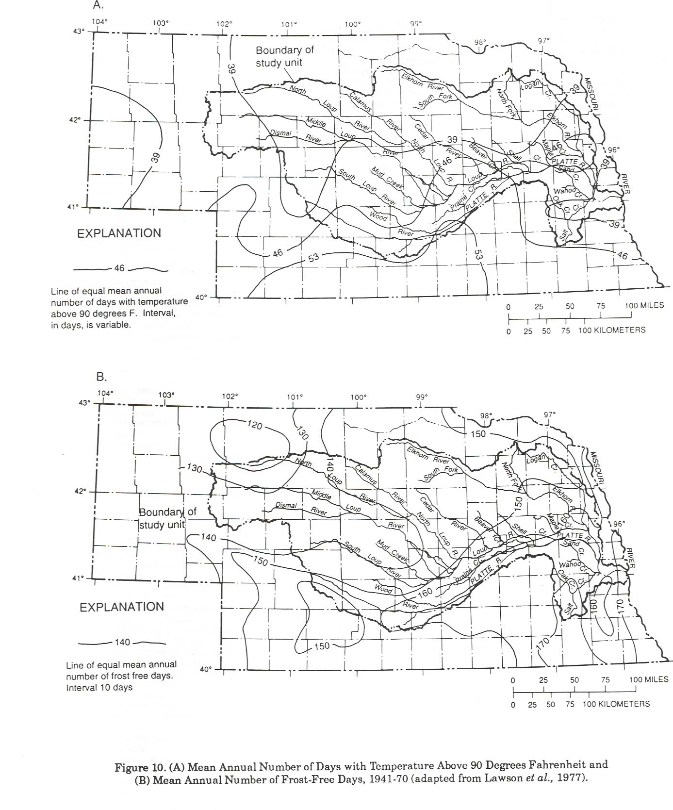
Extended periods of subfreezing temperatures (Figure 9) contrast with periods of intense heat in the summer (Lawson et al., 1977). Mean temperatures in July and August are between 70-75 degrees Fahrenheit, about 20 degrees Fahrenheit in January, and between 25 and 30 degrees Fahrenheit in December and February. Winter temperatures are extremely variable; temperatures during winter can be below -10 degrees Fahrenheit for more than a week but winter temperatures also can be above 70 degrees Fahrenheit. For example, late January temperatures as high as 78 degrees Fahrenheit and as low as -40 degrees Fahrenheit were recorded in the Sandhills. The frost-free growing season varies from more than 170 days (between April 25-October 15) in the east to about 120 days (between May 10-September 30) in the northwest (Figure 10).
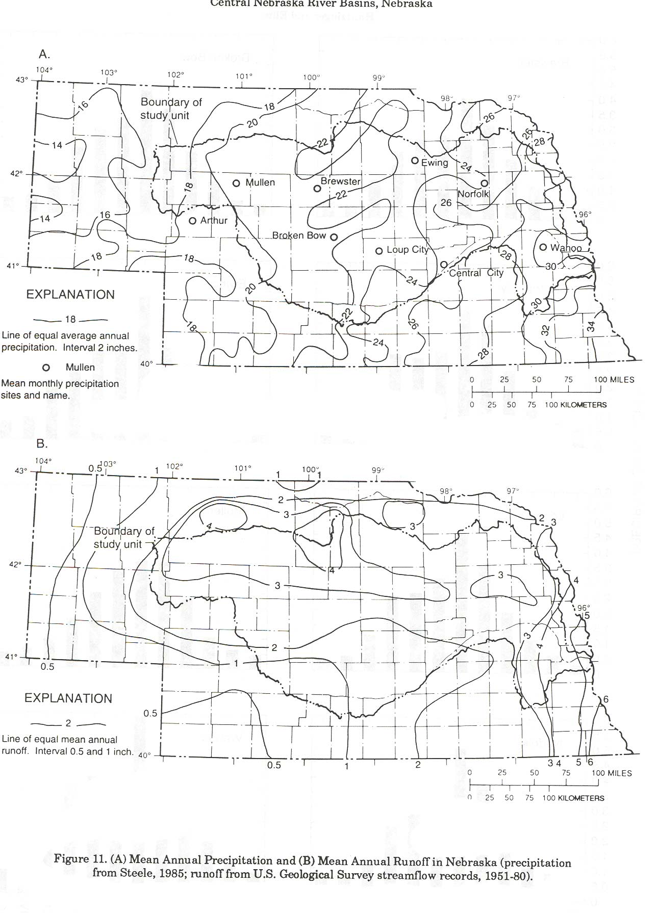
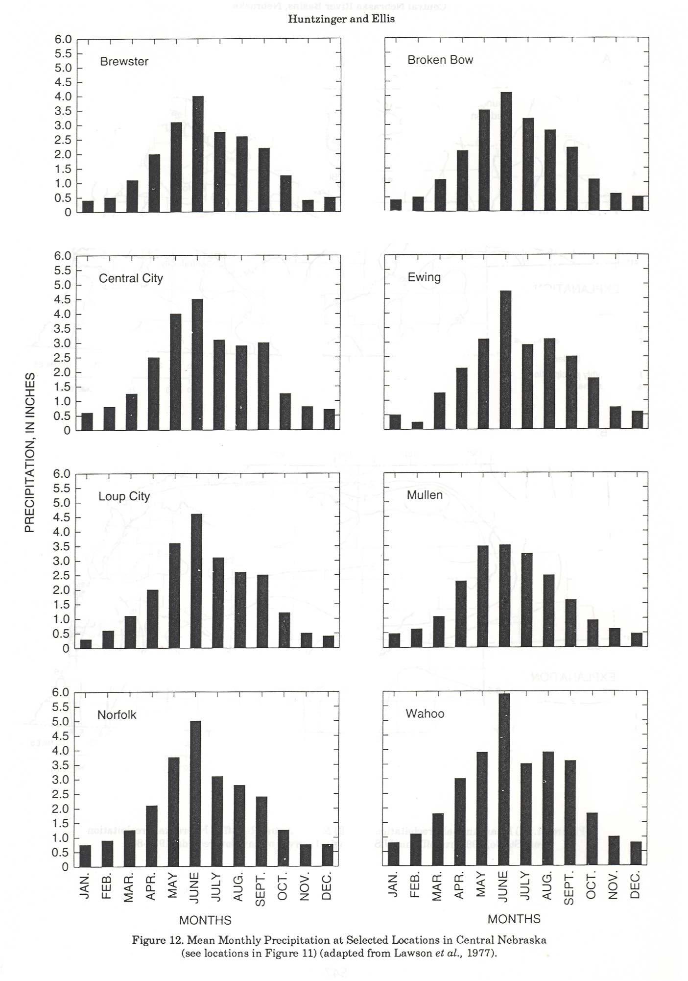
Mean annual precipitation (Figure 11) varies from about 18 inches in the western part of the study unit to about 30 inches in the eastern part. Most of the study unit has at least 20 inches of annual precipitation, and more than one-half occurs during the growing season, April through September. The most rainfall occurs in June when rainfall amounts are more than 3 inches throughout the study unit, with more than 4.5 inches in the east. The late fall and winter, November through February, are drier months with less than 1 inch per month in most locations (Figure 12).
Snowfall is a dominant climatic characteristic of central Nebraska that affects soil moisture conditions (Lawson et al., 1977). Snowfall accumulation in late winter or early spring can contribute to runoff either from snowmelt or from rainfall that rapidly melts the snow. Large accumulations of snow also can saturate the soils during thawing so that normal precipitation runs off or percolates deeper into the subsurface or to the shallow ground water. Mean annual snowfall ranges from about 25 inches in the southeast to about 35 inches in the northwest. Most snowfall occurs at the rate of 5 to 6 inches per month from January through March. Average depth of snow accumulation is 1-2 inches.
Streamflow
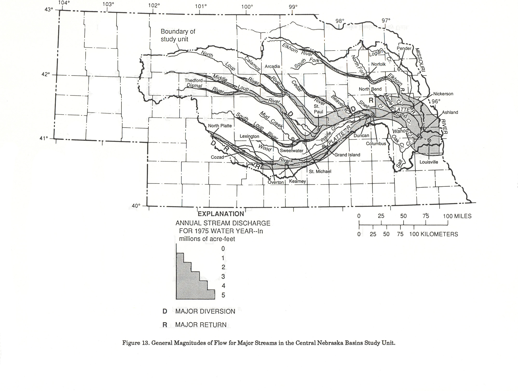
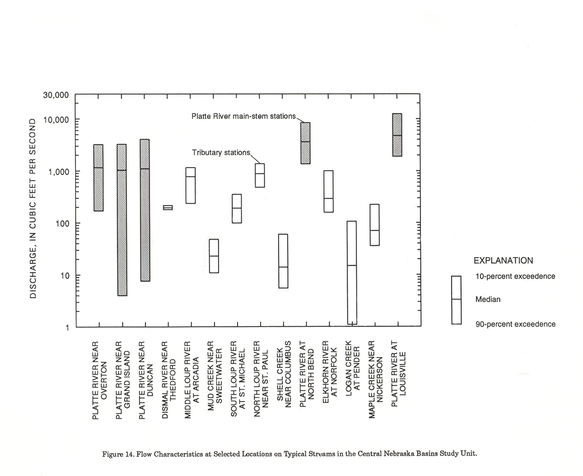
Streams in the study unit include the Platte River and two main tributary systems, the Loup and the Elkhorn Rivers (Figure 13). Salt Creek is a smaller tributary to the Platte River in terms of flow, but it significantly affects water quality in the lower reach of the Platte River because of large dissolved-solids concentrations in shallow ground water originating from mineralized areas of the Dakota Sandstone. The general magnitudes of flow for major streams in the study unit are summarized in Figure 13.
Reservoirs upstream from the study unit and diversions for power generation and irrigation control flow in the Platte River. Many of the tributary streams in the more arid western part of the study unit upstream of Grand Island, where annual precipitation is less than 25 inches, are intermittent, and most flow in them is from snowmelt and runoff from precipitation. Therefore, Platte River flows near Grand Island and Duncan are extremely variable as shown in Figure 14.
In contrast to the Platte River, tributaries to the Loup River are sustained by shallow ground water in the Sandhills and have an extremely consistent base flow. Tributaries located exclusively in the Sandhills have little or no surface runoff, as shown by the uniform flow characteristics of the Dismal River (Figure 14). The base flows of the Loup tributaries and runoff in the eastern part of the Loup River watershed combine to produce larger and more consistent flows in the Platte River at North Bend.
The downstream reaches of the Elkhorn River, its tributaries, Salt Creek, and some downstream tributaries to the Platte River are typical of more humid areas. Flows are affected by large runoff in spring and fall that result from many intense storms on steeper slopes and less permeable soil than occur farther west.
Lakes and Wetlands
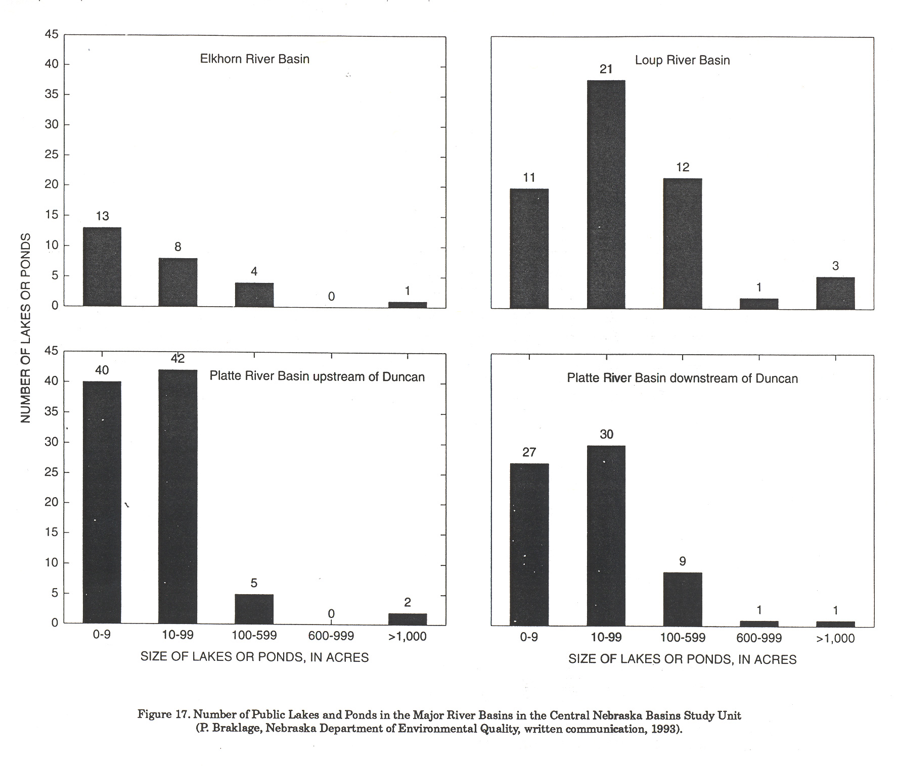
There are about 250 lakes and ponds in the study unit that are identified by the Nebraska Department of Environmental Quality as either publicly owned or have public access (Braklage, 1993). Most of these lakes are small (Figure 17) and are a result of construction of dams or roadways. Only 10 are more than 600 acres in surface area. Other significant lakes and ponds in addition to those included in Figure 17 are permitted by the Nebraska Department of Water Resources (Braklage, 1993) for construction of impoundments or are part of the dam safety program. There are over 1500 impoundments with more than 15 acre-feet of storage in Nebraska that require permits or dam safety inspections. Many other small flood-control ponds were constructed on private land as part of U.S. Department of Agriculture erosion-control programs. There are also natural lakes in the Sandhills that are not included as public-owned or permitted lakes or ponds.
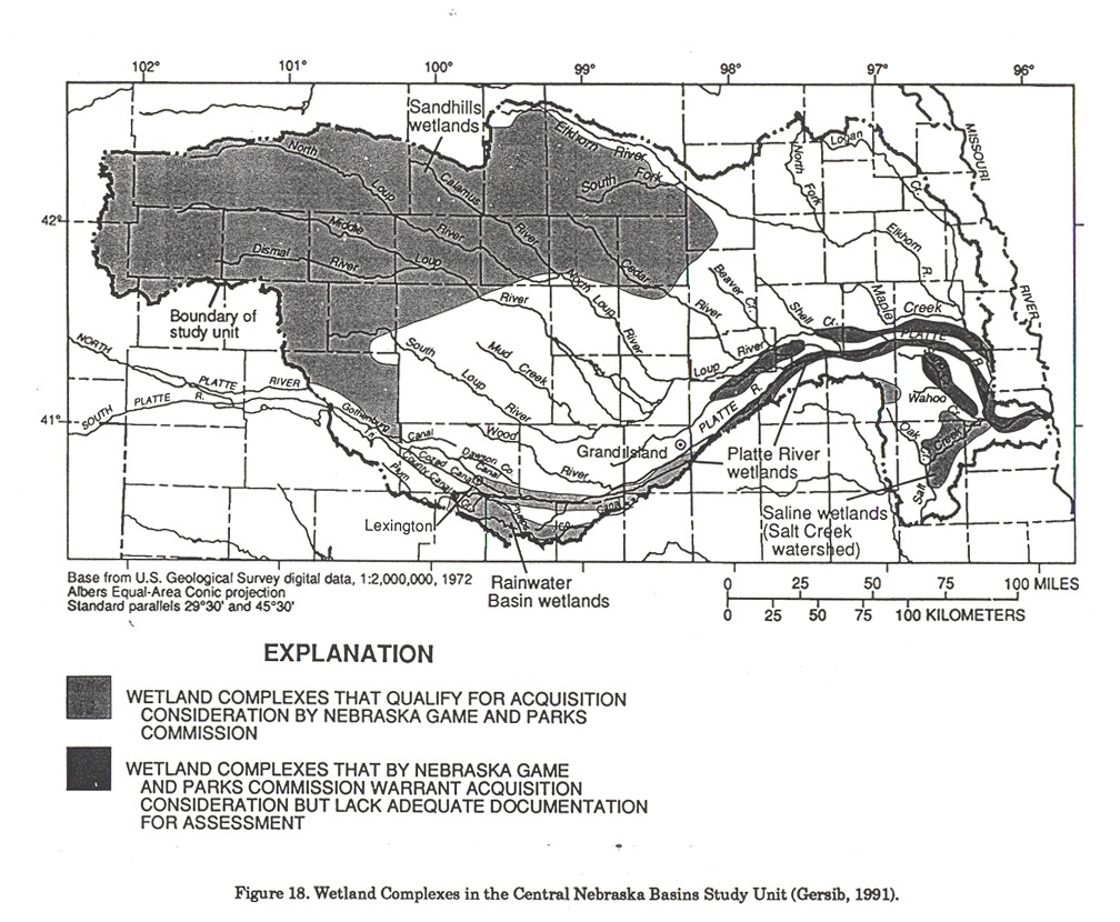
Wetlands also are significant habitats in the study unit. The Nebraska Game and Parks Commission, in cooperation with the U.S. Fish and Wildlife Service, has identified several separate wetland complexes (Gersib, 1991) that are within the study unit (Figure 18). One wetland complex is along the Platte River and adjacent lowlands. Others are small lakes and marshland, or a combination of stream and adjacent marshland in poorly drained areas, in the Sandhills area near the Tri-County Canal, and in the Salt Creek watershed. Platte River wetlands include both the shallow channel and islands and the palustrine (small, shallow wetland) habitat within the historic river channel and flood plain between Lexington and Grand Island, Nebraska. The wetlands near the Tri-County Canal and "Rainwater Basin" wetlands occur in wind-formed depressions where fine soil material transported by surface runoff accumulated and combined with clay subsoils to seal the subsurface with a small permeability "clay pan." Localized areas between the Tri-County Canal and the Platte River are irrigated with surface water, and the water table has risen, which enhances some wetland areas with shallow ground water. Sandhills wetlands occur in valleys or lowlands where the water table is at or near the surface. Therefore, wetlands in the Sandhills are of ground-water origin in contrast to the "Rainwater Basin" wetlands, which are primarily a result of surface runoff. Saline soils and salt-tolerant vegetation characterize saline wetlands in the Salt Creek drainage basin. Salt Creek and some of its tributaries drain areas of saline shallow ground water that sustain eastern wetlands.
Many species of shore birds and migratory wildlife use the wetlands in the study unit. Some of these areas are critical habitat for threatened and endangered species, such as the bald eagle, whooping crane, interior least tern, piping plover, and peregrine falcon (Gersib, 1991). The western prairie fringed orchid is one plant found in the Platte Valley that is included on the list of threatened or endangered species (Gersib, 1991). Geographically, the Platte River and adjacent areas serve as a seasonal resting and feeding area for migratory birds. During the spring, nearly one-half million Sandhill cranes, 80 percent of the North American population, use the Platte River and adjacent feeding grounds at a critical stage in their biological cycle. The reach of the Platte River from Lexington to Grand Island is considered critical habitat for the population recovery of the whooping crane, an endangered species. Millions of migratory waterfowl, other than cranes, use the Platte and "Rainwater Basin" wetlands. Over 300 migratory bird species, which includes 75 percent of the species on the Audubon Society "blue list" of species in jeopardy, have been observed along the Platte River (Gersib,1991). About 200 bald eagles winter on the Platte River between Lexington and Grand Island, and interior least terns and piping plovers nest on the barren sand bars in the Platte River channel.
Water Use
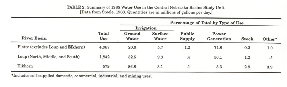
Most of the water in the study unit is consumed by irrigation or used for power generation and returned to the stream for reuse. A summary of water use in Table 2 shows that the quantity of water used for irrigation is primarily from ground water. The few urban areas in the study unit, such as Lincoln and Grand Island, use ground water as a municipal water supply, most of which is withdrawn from the alluvium along the Platte River. The city of Omaha immediately to the east of the study unit, north of the Platte River, obtains part of its water supply from wells in the Elkhorn and Platte River Valleys.
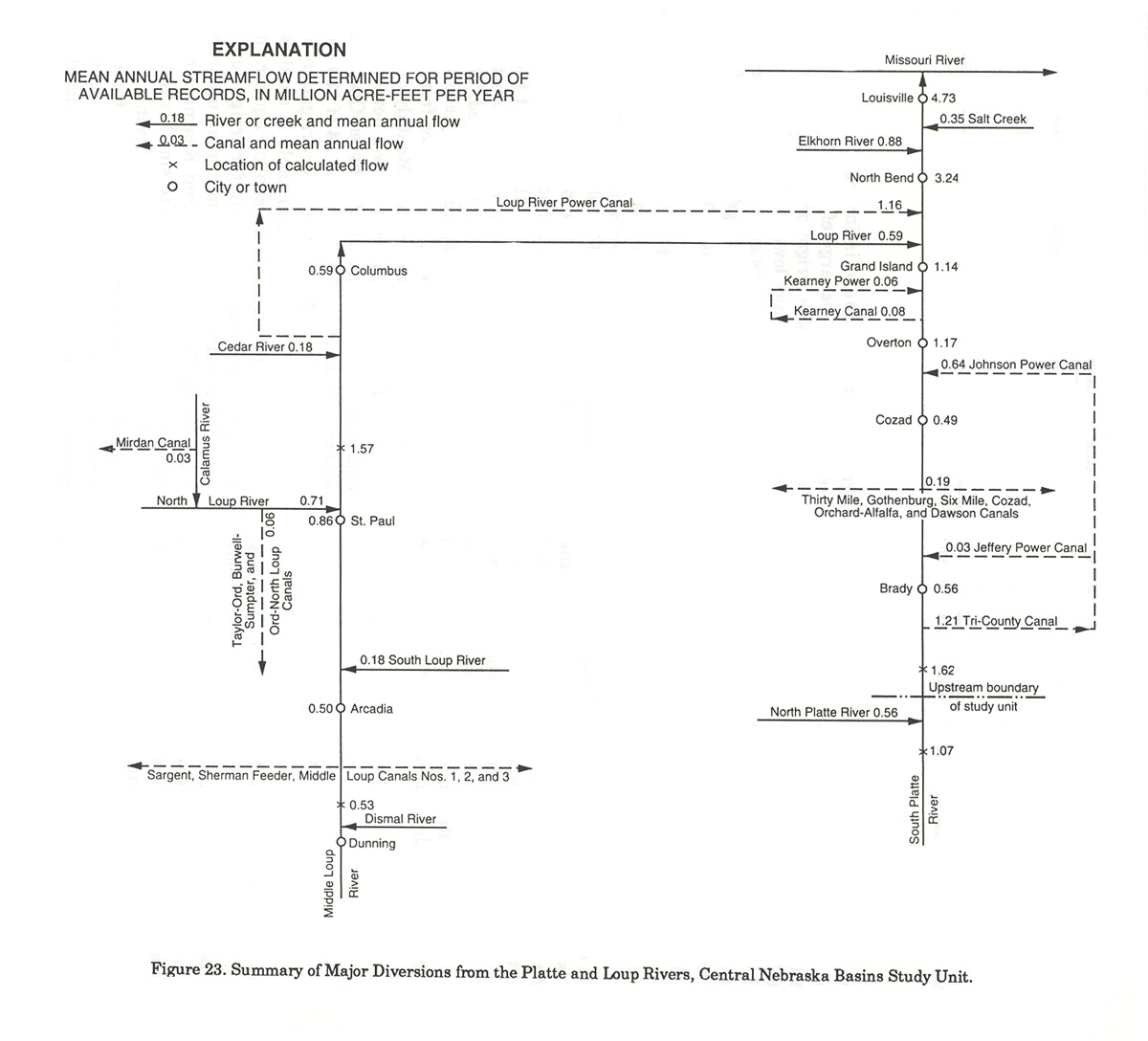
Diversions of surface water for irrigation and power generation greatly affect the Platte River upstream from Kearney (Nebraska Natural Resources Commission, 1984). The canal systems diagramed in Figure 23 show that mean flow of the Platte River as it enters the study unit is about 1.62 million acre feet per year (flows of North Platte and South Platte Rivers plus canal return flows to the South Platte River). About 1.21 million acre-feet of water is diverted to the Tri-County Supply Canal and an additional 0.19 million acre-feet is diverted to other canals upstream from Cozad. The smallest mean annual flow of the Platte River within the study unit, 0.49 million acre-feet, occurs just upstream from the Johnson Power Canal return near Cozad. At this point about one-half of the flow is water gained from tributary runoff, irrigation return flow, or ground water. The Johnson Power Canal return flows of 0.64 million acre-feet plus gains to the river from tributary runoff, irrigation return flow, and ground water restore mean annual flows of the river at Overton to about 1.17 million acre-feet. The Kearney Canal diversion and return flows then result in mean annual flow in the Platte River of about 1.14 million acre-feet near Grand Island, which is less than the mean annual flow at the study-unit boundary.
Diversions from the major tributaries of the Loup River are not as large as those from the Platte River. However, 0.19 million acre-feet per year, or more than 35 percent of the Middle Loup River mean annual flow, is diverted upstream of Arcadia. Less than 10 percent of the mean annual flow of the North Loup River is diverted upstream of the confluence of the Calamus River, and less than 5 percent is diverted between the Calamus River and St. Paul. The Loup River Power Canal mean annual diversion of 1.16 million acre feet, or 66 percent of the mean annual flow of the Loup River upstream of Columbus, is conveyed to the Platte River downstream of the mouth of the Loup River.
Environmental Subunits
Regional ecology concepts are described by Omernik (1987) that are based on similarities in habitat. Application of these ideas has defined four ecoregions in Central Nebraska (Omernik and Gallant, 1987). The eastern part of the study unit that includes primarily the Elkhorn River basin in the glaciated area is described by Omernik (1987) as the Western Corn Belt Plains which were originally tall-grass prairie that has been converted to cropland. The Sand Hills area comprised of dunes covered with prairie grasses has been identified as a separate ecoregion and is called the Nebraska Sandhills. The south-central part of the study unit has been defined as the northern end of the Central Great Plains ecoregion that was originally mixed prairie grasses and is now a mixture of pasture and irrigated and nonirrigated croplands. A small portion of the upper Elkhorn River basin immediately east of the Sandhills was included in the Northern Glaciated Plains that were originally tallgrass prairie and is now primarily cropland. The Northern Glaciated Plains differ from the Western Corn Belt Plains primarily in topography; the Western Corn Belt Plains are not as flat as the Northern Glaciated Plains.
Ecoregions as identified by Omernik and Gallant (1987) are comparable to the environmental subunits used in the National Water Quality Assessment in central Nebraska with two major differences. The Platte River valley is considered a separate subunit, and the Northern Glaciated Plains and Western Corn Belt Plains have been combined into one subunit called the Glaciated Area.
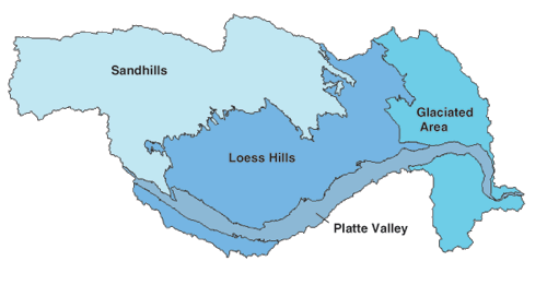
The study unit has been divided into four major subunits (Figure 24), whose boundaries are defined primarily by similarities in surface materials, land forms, general land use, and hydrogeologic units. Features that characterize major subunits form an organizational structure that becomes the basis for water-quality assessment, both in the collection of data and its interpretation. Hydrologic units defined by drainage boundaries are not compatible with the environmental subunit boundaries; however, there are watersheds of many streams that are primarily within single subunits. In terms of ground water, each subunit is underlain by the shallow and regional systems described previously in this report. The four environmental subunits are described below.
The Sandhills subunit is a large area characterized by grass-stabilized sand dunes. This subunit generally includes the area from the western limit of the Loup drainage downstream or eastward to the limit of surface sand, which is interspersed with loess deposits near its eastern boundary. The surface sand deposits have topographic relief of several hundred feet and range in thickness from a few feet to more than 400 feet. These shallower deposits are not a commonly used source of water because the thicker deposits are usually at inaccessible locations on the crest of dunes. Wetlands and lakes often exist in valleys between dunes where the water table is at or near the surface. The underlying alluvial deposits of Quaternary age and the Ogallala Formation of Tertiary age are the primary sources of ground water in the subunit. Alluvial deposits of Quaternary age tend to be thin in the western part of the Sandhills subunit because of post-depositional erosion or nondeposition. The Ogallala Formation underlies the entire Sandhills subunit, but becomes thinner and finer grained toward the east. Infiltration rates in this subunit are so great that little runoff occurs, and streams show slow and dampened response to precipitation. Rangeland covers major parts of the subunit, with small discontinuous areas of cropland in interdune areas and near streams. In the eastern part of the Sandhills, where sand sheets occur, irrigated cropland is common.
The Loess Hills subunit is an area of loess-mantled hills and eroded plains. Most of the eroded plains occur on the north side of the Platte River. Alluvial deposits of Quaternary age generally are the principal source of ground water in the eastern one-third of the subunit because the Ogallala Formation is thin or absent. In the western one-third of the subunit, the Ogallala Formation is the principle source of ground water because the Quaternary deposits may be absent, thin, or unsaturated. Irrigation of row crops affects the water quality in this subunit because of the intensive use of agricultural chemicals for long-term corn production with minimal crop rotation. Diversion from streams to irrigate uplands has the potential to affect the ground-water quality in several areas, particularly where the water table is less than 50 feet from the surface. For example, the water-table elevation has increased more than 100 feet in the uneroded plains area south of the Platte River because of the diversion of water from the Platte River for irrigation. Elevated concentrations of nitrate in ground water in this subunit are evidence of the effects of agriculture on water quality (Exner and Spalding, 1990).
In the Platte Valley subunit, ground water in the Quaternary alluvial deposits has a direct hydraulic connection with the Platte River. Ground water gradients and water quality are affected by flows in the river and by diversions and return flows of surface water used for irrigation and power generation. Control structures upstream of the study unit and river-management policy for diversion of surface water for irrigation and power generation have resulted in decreased peak flows in the reach between North Platte and Grand Island. When the river stage is high, the ground-water system is recharged directly from the river; during periods of low river stage, streamflow is maintained by discharge of ground water into the stream channel. Stream diversions for irrigation in the Platte Valley have resulted in local water-level rises and the potential for water-quality effects. Large quantities of water for irrigation are pumped from the alluvial deposits of Quaternary age and the Ogallala Formation in the Platte Valley. Widespread use of agricultural chemicals has affected the quality of water in most of the subunit as indicated by elevated concentrations of agricultural chemicals found in ground and surface water (Exner and Spalding, 1990).
The Glaciated Area subunit is characterized by loess-derived fine-grained soils of small permeability and steep topography. The alluvial deposits of Quaternary age described earlier are the principal sources of ground water in the Glaciated Area. Deposits of Quaternary age in part of the Glaciated Area are underlain directly by the Dakota Sandstone. The Dakota Sandstone commonly is a supplemental or alternate source of ground water; however, yields are variable and water from the Dakota contains large concentrations of dissolved solids in some areas, such as the Salt Creek watershed. This subunit has an average annual precipitation that exceeds 25 inches, commonly sufficient to sustain crops without extensive irrigation. Intense rain-storms, usually in spring, occurring on the steep slopes result in large surface runoff. Land use in the subunit is primarily row crop mixed with pasture (less than 15 percent).
References
Bazata, Kenneth, 1991. Nebraska Stream Classification Study. Nebraska
Department of Environmental Control, Water Quality Division Report,
342 pp.
Beckman, Emil W., 1976. Magnitude and Frequency of Floods in Nebraska.
U.S. Geological Survey Water Resources Investigation 76-109,
127 pp.
Bentall, R. et al., 1971. The Elkhorn River Basin of Nebraska,
Water Supplies and the Land. Conservation and Survey Division, Institute
of Agriculture and Natural Resources, University of Nebraska-Lincoln,
Lincoln, Nebraska, Resource Atlas No. I, 51pp.
Bentall, R. et al., 1975, Hydrology, Nebraska Mid-state Division
and Associated Areas. Conservation and Survey Division, Institute
of Agriculture and Natural Resources, University of Nebraska-Lincoln,
Lincoln, Nebraska, 256 pp.
Bleed, A. and C. Flowerday (Editors), 1990. An Atlas of the Sand
Hills. University of Nebraska, Conservation and Survey Division,
Institute of Agriculture and Natural Resources, University of Nebraska-Lincoln,
Lincoln, Nebraska, Resource Atlas No. 5a, 265 pp.
Braklage, P., 1993. Public Lakes and Ponds in Nebraska. Nebraska
Department of Environmental Quality, written communication, 41 pp.
Conservation Survey Division, 1986. The Groundwater Atlas of Nebraska.
Conservation and Survey Division, Institute of Agriculture and Natural
Resources, University of NebraskaLincoln, Lincoln, Nebraska,
Resource Atlas No.4, 32 pp.
Dugan, J. T., 1984. Hydrologic Characteristics of Nebraska Soils.
U.S. Geological Survey Water Supply Paper 2222, 19 pp., 4 plates.
Dugan, J. T. and R. B. ZeIt, 1992. Simulation of Soil-Water Conditions
in the Great Plains and Adjacent Areas, 1951-80. U.S. Geological
Survey Water-Resources Investigations Report (written communication),
153 pp.
Elder, J. A., 1969. Soils of Nebraska. University of Nebraska,
Conservation and Survey Division Resource Report No.2, 60 pp.
Ellis, M .J. and G. B. Steele, 1990. Ground-Water Levels in Nebraska
1989. University of Nebraska, Conservation and Survey Division,
Nebraska Water Survey Paper Number 67, p.3.
Engberg, R. A., 1983. A Statistical Analysis of the Quality of
Surface Water in Nebraska. U.S. Geological Survey WaterSupply
Paper 2179, 252 pp.
Engberg, R. A., 1984. Appraisal of Data for Ground-Water Quality
in Nebraska. U.S. Geological Survey Water-Supply Paper 2245, 54
pp.
Engel, G. B. and E. E. Fischer, 1991. Nebraska Floods and Droughts.
In: National Water Summary 1988-89 - Hydrologic Events
and Floods and Droughts, Richard W. Paulson, Edith B. Chase, Robert
S. Roberts, and David W. Moody (Compilers). U.S. Geological Survey
Water Supply Paper 2375, pp. 377-384.
Eschner, T. R, R F. Hadley, and K. D. Crowley, 1983. Hydrologic
and Morphologic Changes in Channels of the Platte River Basin in
Colorado, Wyoming, and Nebraska: A Historical Perspective. U.S.
Geological Survey Water Supply Paper 1277-A, 39 pp.
Exner, M. E. and R F. Spalding, 1990. Occurrence of Pesticides
and Nitrate in Nebraska's Ground Water. Water Center, Institute
of Agriculture and Natural Resources, University of Nebraska, Lincoln,
Nebraska, 34 pp.
Federal Energy Regulatory Commission,1992. Draft Environmental
Impact Statement: Kingsley Dam (FERC Project No. 1417) and North
Platte/Keystone Diversion Dam (FERC Project No. 1835) Projects,
Nebraska. Division of Public Information, Federal Energy Regulatory
Commission FERC/DEIS-0063, 372 pp.
Gersib, R A., 1991. Nebraska Wetlands Priority Plan. Nebraska Game
and Parks Commission, 56 pp.
Goolsby, D. A., R C. Coupe, and D. J. Markovchick, 1991. Distribution
of Selected Herbicides and Nitrate in the Mississippi River and
Its Major Tributaries, April Through June 1991. Water Resources
Investigations Report 91-4163, 35 pp.
Gutentag, E.D., F. J. Heimes, N. C. Krothe, R R. Luckey, and J.
B. Weeks, 1984. Geohydrology of the High Plains Aquifer in Parts
of Colorado, Kansas, Nebraska, New Mexico, Oklahoma, South Dakota,
Texas, and Wyoming. U.S. Geological Survey Professional Paper
1400-B, 63 pp.
Huntzinger, T. L., 1991. National Water-Quality Assessment Program
- Central Nebraska Basins. U.S. Geological Survey Open File Report
91-97 (Water Fact Sheet), 2 pp.
Jensen, M. E., J. C. Wright, and B. J. Pratt, 1969. Estimating
Soil-Moisture Depletion from Climate, Crop, and Soil Data. American
Society of Agricultural Engineers, Paper 69-941, 26 pp.
Lawson, M. P. et al., 1977. Climatic Atlas of Nebraska. University
of Nebraska Press, Lincoln, Nebraska, 88 pp.
Leahy, P.P., J.S. Rosenshein, and D. S. Knopman, 1990. Implementation
Plan for the National Water-Quality Assessment Program. U.S. Geological
Survey Open File Report 90-174, 10 pp.
Lohman, S. W., 1979. Ground-Water Hydraulics. U.S. Geological Survey
Professional Paper 708, p. 6.
Matthai, H. F., 1968. Magnitude and Frequency of Floods in the
United States. Part 6-B. Missouri River Basin Below Sioux City,
Iowa. U.S. Geology Survey Water-Supply Paper 1680, 491 pp.
Matthai, H. F., 1969. Floods of June 1965 in South Platte River
Basin, Colorado. U.S. Geological Survey Water-Supply Paper 1850-B,
pp. 5-7.
Nebraska Natural Resources Commission, 1984, Policy Issue Study
on Supplemental Water Supplies. Supplemental Water Supplies Report,
153 pp.
Nebraska Natural Resources Commission (no date). Nebraska Natural
Resource Districts: Unique, Progressive Leadership in Conservation.
Nebraska Natural Resources Commission Pamphlet, 15 pp.
Omernik, J. M., 1987. Ecoregions of the Conterminous United States.
Annals of the Association of American Geographers, Vol. 77, pp.
118-125.
Omernik, J. M. and A. L. Gallant, 1987. Ecoregions of the West
Central United States. Environmental Research Laboratory, Corvalis,
Oregon, U.S. EPA Publication EPA/600/D-87/317, 1 sheet, scale 1:7,500,000.
Spalding, R F. and D. D. Snow, 1988. Stream Levels of Agrichemicals
During a Spring Discharge Event. Chemisphere 19(8/9): 1129-1140.
Stamer, J.K. and P. R. Jordan (Editors), 1991. Surface Water-Quality
Assessment of the Lower Kansas River Basin, Kansas and Nebraska.
Analysis of Available Data Through 1986. U.S. Geological Survey
Open File Report 91-75, 171 pp.
Steele, E. K., Jr., 1988. Estimated Use of Water in Nebraska, 1985.
Nebraska Water Survey Paper No. 64, 125 pp.
U.S. Department of Commerce, 1959. Climates of the States, Nebraska.
Climatography of the United States, No. 60-25, 16 pp.
U.S. Department of Commerce, 1989. 1987 Census of Agriculture,
Nebraska State and County Data. Bureau of the Census, Geographic
Area Series, 499 pp.
U.S. Environmental Protection Agency, 1992. Drinking Water Regulations
and Health Advisories, November 1992. Office of Water, Washington,
D.C., 256 pp.
U.S. Fish and Wildlife Service, 1981. The Platte River Ecology
Study. U.S. Fish and Wildlife Service Special Research Report, 187
pp.
U.S. Geological Survey, 1991. National Water Summary 1988-89 -Hydrologic
Events Floods and Droughts. U.S. Geological Survey Water Supply
Paper 2375, p. 377.
Williams, G. P., 1978. The Case of the Shrinking Channels - The
North Platte and Platte Rivers in Nebraska. U.S. Geological Survey
Circular 781, 48 pp.
Previous page
|

