
"Reprinted" from Nebraska Farmer, May 1994, v.136, no.8, p.10-13.
Spring Herbicide "Flush" May Deal Cities a Problem |
| USGS sampling of Platte River water shows atrazine, Bladex levels highest after spring storms; atrazine averages below its MCL |
By John Stamer and Thomas Huntzinger |
HTML Coding by Kurt Davis; Graphics by Ron Zelt and Mark Lippincott |
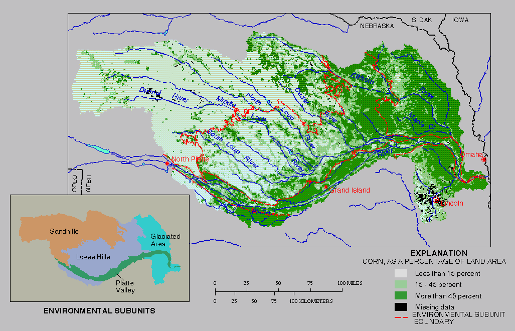 |
| Map shows the USGS study unit in Nebraska. Most corn is produced in the eastern part of the study area and in the Platte River Valley. Map does not include a big portion of the panhandle and portions of northern and southern Nebraska. |
After intense spring rains, concentrations of atrazine, alachlor (Lasso) and cyanazine (Bladex) increase in the Platte River, posing a potential threat to public water supplies, including the Lincoln wellfield near Ashland.
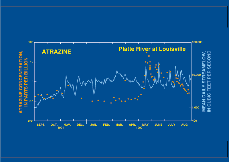
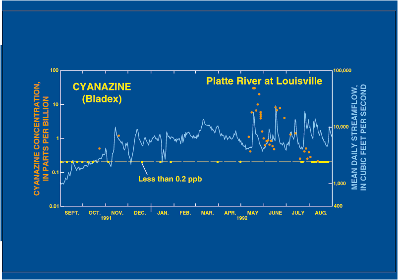
Herbicide concentrations in Platte River water at Louisville, about 10 miles downstream from the Lincoln wellfield, generally were measured weekly, sometimes more frequently, by the U.S. Geological Survey for 1 year, ending Aug. 31, 1992. The highest concentration of atrazine, alachlor, cyanazine and metolachlor (Dual) in Platte River water at Louisville occurred during runoff from intense spring rains, shortly after herbicide application. These herbicides are among the most commonly used in Nebraska.
Annual average concentrations of atrazine and alachlor for the 1-year period appear to have been less than the maximum contaminant levels (MCLs) of 3 and 2 parts per billion (ppb), respectively, established by EPA, even though the concentrations of the two herbicides were high during spring runoff.
The average concentration of cyanazine, however, may have exceeded the 1 ppb health advisory level (HAL). Metolachlor did not exceed its 100 ppb HAL. (An MCL is a regulated standard for finished public water supplies, while an HAL is a guideline, If the annual average reading for a compound exceeds its MCL, the public water supply is not in compliance with EPA regulation. The annual average measurement is based on a minimum of four samples that must be taken.)
The movement of herbicides into surface water is being examined by USGS as parts of its National Water Quality Assessment (NAWQA) and Toxic Substances Hydrology Program. The "Central Nebraska Basins" (CNB), which includes part of the Platte River Basin in Nebraska, is one of 60 NAWQA study units nationwide. The program is desinged to assess the status and long-term trends in the quality of the nation's water resources and to determine how natural factors and human activities affect these resources. Surface water quality data, including pesticide information, will be collected by USGS at numerous sites in the basin through the end of 1994. Water sampling will continue after then, but on a less frequent basis.
The Nebraska study area is important because little information currently exists on the occurrence and transport of herbicides in the Platte River and its tributaries.
Many municipalities, including Lincoln, obtain their water from wells in the aquifer adjacent to the Platte River. River water containing herbicides in solution can move from the river into the aquifer, where it is pumped from wells to the water treatment plants. Conventional water treatment is ineffective in removing herbicides from the finished supply.
Study results will provide information for agencies, such as the Nebraska Department of Agriculture, which now administers the Federal Insecticide, Gungicide, and Rodenticide Act (FIFRA). LB588, passed in the 1993 Nebraska Legislature, gives the department authority to regulate pesticide use.
USGS collected water samples from the Platte River at Louisville because the water quality at that site represents water water quality conditions for the entire basin. The USGS also collected surface water samples in May 1992 at four upstream sites. Three of those sites drain areas characterized by different land use and topography within the basin. The fourth site is near North Platte where the North Platte and South Platte Rivers merge.
The study area drains approximately 30,000 square miles (see map), about half of which is rangeland and pasture. The other half is cropland. The major crops are corn, soybeans, sorghum and wheat. Most of the corn is grown in the eastern portion of the basin and in the Platte River Valley. Of the four aforementioned herbicides, atrazine is the most extensively applied. An estimated 3.1 million pounds of atrazine were used in the basin in 1991, according to USDA.
Some specific study results to date are:
Higher concentrations of the four herbicides probably would have occurred had streamflows in May and June 1992 been near normal. Instead, streamflow in those 2 months in 1992 was about 64 percent of the long-term average for those months.
Communities such as Lincoln obtain their water from wells drilled in the shallow aquifer near the Platte River. With their large-capacity wells, water and the compounds in solution are drawn from the aquifer to the treatment plant.
Conventional water treatment, such as coagulation, sand filtration and chlorination, is ineffective in removing these herbicides. The herbicides remain in solution, in contrast to other compounds that are more easily removed. Lincoln uses no special treatment, such as activated carbon or ozonation, to lower concentrations of these herbicides.
EPA requires that public water utilities measure regulated herbicides in finished water a minimum of four times a year to determine compliance with regulations. At least one of the four samples is to be collected during spring when concentrations generally are expected to be the highest. Thus, if one of the four atrazine concentrations exceeded 12 ppb, the annual average concentration would exceed the MCL of 3 ppb and would result in non-compliance with the EPA regulation.
-- John Stamer and Thomas Huntzinger are hydrologists with the USGS in Lawrence, KS.
Editor's Note : Use of trade names in this article is for
identification purposes only and does not constitute endorsement or condemnation
by the U.S. Geological Survey.
Atrazine Concentration | ||||
|---|---|---|---|---|
|
||||
| Concentrations of atrazine varied seasonally, with the highest concentrations occurring in the spring and summer and the lowest concentrations in the fall and winter. | ||||
Cyanazine Concentration | ||||
|---|---|---|---|---|
|
||||
| Concentrations of cyanazine (Bladex) varied in a manner similar to atrazine. However, concentrations of cyanazine generally were less than 0.2 parts per billion (ppb) from September 1991 until the early part of May 1992. | ||||
|
||||||||||
|
||||||||||