
Survey data were converted to geospatial data sets using geographicinformation system (GIS) software. Spatial analyses were performed to deriveparameters such as cross-channel stationing, downstream stationing, channelwidth and cross-sectional area, and total shoreline length. Channel widthincreased an average 4 feet (from 370 to 374 feet) in the upstream reach andwas unchanged in the downstream reach. Bankfull width, bankfull width-to-depthratio, and total shoreline length per unit reach length were at least threetimes greater in the braided downstream reach than in the meandering upstreamreach. Channel slope was about 13 percent steeper in the downstreamreach. Lateral channel migration of 4 feet was measured in part of theupstream reach. Downstream migration of sand bars was observed in thedownstream reach. Unusually high streamflows in 1995 resulted in greaterchange than was observed between the 1993-94 surveys. Flood deposits closedsome small channels, which potentially initiated island expansion. Historicalrecords indicate that some measured changes reflect continuing longer termprocesses. Of nine fish taxa identified as being in serious decline in theCentral Plains region, only the Flathead chub and the Speckled chub wereobserved during sampling of the study reaches.
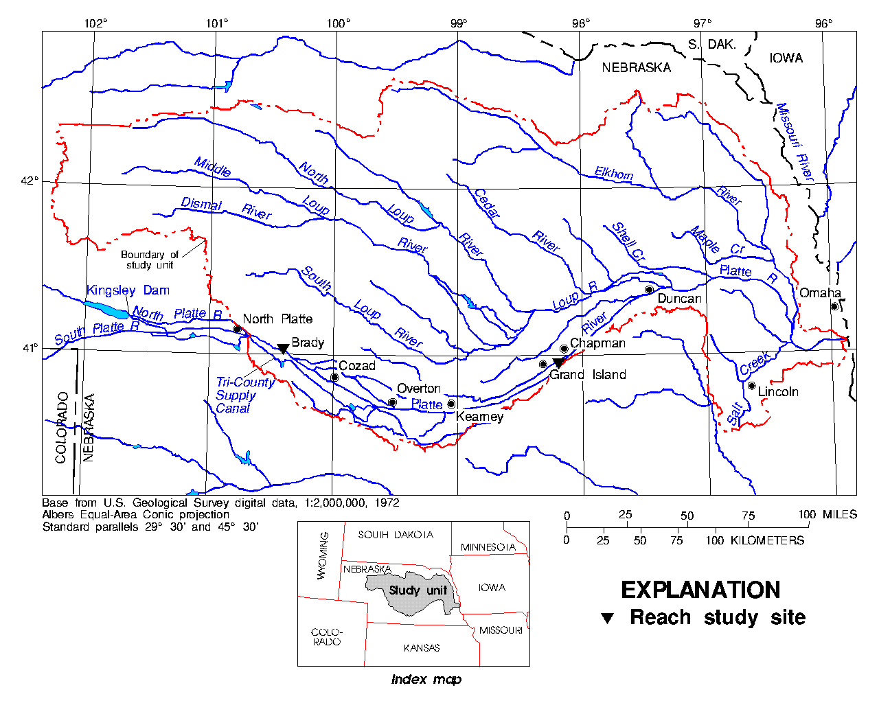
Figure 1 -- Location of Central Nebraska Basins study unit and reaches studied during 1993-95.
Beginning in 1991, the U.S. Geological Survey (USGS) began a study of the Central Nebraska Basins (CNB), which includes the Platte River and many of its tributaries (fig. 1). The study is a component of the USGS's National Water-Quality Assessment Program (NAWQA), which is designed to describe the status and trends in the quality of the Nation's surface- and ground-water resources and to provide a sound understanding of the natural and human factors that affect the quality of these resources. Water quality is broadly defined to include the physical, chemical, and biological components of stream and aquifer systems. Thus, in the CNB component, some of the important questions to address concern the ecological health of the Platte River--"Are the previously described trends in channel size and island stabilization by woody vegetation continuing? How do changes occurring in Platte River habitat affect the resident fish communities?" This paper presents some of the results of initial NAWQA activities undertaken to answer these questions.
Knowledge of the streamflow regime is critical for understanding the Platte River. Streamflow downstream from North Platte is affected by diversions into the Tri-County Supply Canal about 17 mi upstream from Brady and by the operation of Kingsley Dam on the North Platte River about 53 mi farther upstream. These diversions began in November 1940, and Kingsley Dam began storage in February 1941. Given the streamflow alterations introduced in 1940-1941, the current hydrologic regime is considered to have begun with the 1942 water year (that is, the year beginning October 1, 1941). Empirical support for the notion that 1942 marks the onset of the current hydrologic regime is provided by Williams' (1978) summary of streamflow data from six Platte River gaging stations. Numerous other reservoirs, diversions, and return flows also have affected the streamflow since at least the 1880s. The first major storage reservoir in the South Platte River Basin was constructed in 1904 (Riverside Reservoir, Colo., capacity 57,500 acre-ft; Kircher and Karlinger, 1983), whereas the first major reservoir in the North Platte River Basin was constructed in 1909 (Pathfinder Reservoir, Wyo., capacity 1,070,000 acre-ft). Compared with the present, cumulative reservoir storage was relatively small until 1909 (Bentall, 1975). Because no streamflow records exist for the Platte River prior to the 1890s, streamflows measured prior to 1909 most closely represent natural flows (Williams, 1978).
Eschner and others (1983) found that upstream from the confluence with the Loup River, the width of Platte River channels in 1979 ranged from 8 to 50 percent of the 1860 widths. They reported evidence that the processes of width reduction were island formation and subsequent attachment of islands to the flood plain or to other islands. Once stabilized by woody vegetation, an island tends to aggrade by increasing roughness and decreasing stream velocity when submerged.
Kircher and Karlinger (1983) found that low flows, more than high flows, have been affected by water development in the Platte River Basin. By dividing the streamflow records into 10-year intervals and comparing those, they observed that hydrologic changes (that resulted in channel change) first affected the upstream reaches and progressively extended downstream. They concluded that reaches upstream from Overton had reached a relatively stable state by about 1950, but that downstream from Overton the river was still adjusting toward stability through the late 1970s.
Following an extreme flood on a sand-bed tributary to the South Platte River, Osterkamp and Costa (1987) documented channel changes and processes by which channel narrowing and flood plain reconstruction occurred. They found that (1) new vegetation on channel bars reduced stream velocities during inundation, causing relatively rapid aggradation of the bar surfaces; and (2) channel islands developed stabilizing woody vegetation and caused channel narrowing by coalescing with other islands and flood-plain edges.
In an extensive study of woodland expansion into formerly active channels of the Platte, Johnson (1994) found that this expansion had followed an upstream-to-downstream spatial migration and that the temporal pattern of expansion is explained largely by streamflows (both magnitude and timing) during the willow and cottonwood seed-dispersal period from mid-May through July. Johnson suggested that mean June streamflows of about 2,800 cubic ft per second (ft³/s) covered most of the active channel, thus curtailing seed germination. He also concluded that the historical trends of channel narrowing and woodland expansion have ceased because streamflows have reached an equilibrium with active-channel area.
Currier (1995) used aerial videography to document Platte River channel changes from 1988 to 1994. He found that channel widths had decreased an average of 26 percent from 1988 widths in the reach from Kearney to Chapman, mostly due to expanded areas of woody vegetation. Currier also estimated that the flood of 1995 removed less than 25 percent of the 3- to 5-year old saplings and removed few of the vegetated islands formed since 1988. However, higher flows may clear large amounts of woody vegetation; open-channel areas increased as total woody vegetation decreased by an average 13 percent as a result of the 1983 flood (M.D. Carlson, U.S. Fish and Wildlife Service, Grand Island, unpublished data, 1987).
The use of peak flows to rehabilitate and maintain the habitat of the Platte River ecosystem has been identified as a high priority by the U.S. Fish and Wildlife Service (USFWS); its May 1994 workshop concluded that woodland expansion should be managed using peak flows rather than by continuous inundation of the active channel during the seed-dispersal period (Bowman and Carlson, 1994). USFWS identified May and June as the period when peak flows are most beneficial for stream habitat maintenance, and recommended that the 10-year moving average of annual peak flows range from 8,300 to 10,800 ft³/s.
The assemblage of fish species in a given reach is the result of numerous abiotic and biotic factors. Abiotic factors in total can be considered a physical-habitat template for that assemblage (Southwood, 1977). Deviations from that template likely would result in an altered fish assemblage. Stream width and velocity, substrate type, and hydrologic variability are important components of the habitat template (Schlosser, 1982; Poff and Allan, 1995). Whereas these aforementioned components vary naturally in space and time, they also are subject to human modification.
Periodic floods create and maintain the instream habitats to which a fish assemblage has adapted (Resh and others, 1988). The elimination of peak flows can be considered a disturbance, albeit a chronic disturbance. Likewise, the periodic inundation of flood plains is important to carbon and nutrient cycling as well as exposing spawning and nursery habitat. Reduced access to those habitats can substantially affect species dependent upon them. In the Platte River, fish assemblages have been described infrequently but reveal a clear trend toward greatly reduced distributions of species that are characteristic of shifting, sand-bottom streams (Tabor, 1993).
For the present study, streamflow records were summarized separately for periods before and after the beginning of the 1942 water year. A complete record of daily streamflow since April 1934 was available for the Grand Island gaging station. However, only 8 years of daily streamflow data were available for the north channel at Brady--water years 1969, 1988, and 1990-95. Therefore, in addition to the north channel record, the record for total flow (north and south channels combined) at Brady also was summarized because it extends from water years 1939-95.
Channel geometry was surveyed in 1993, 1994, and 1995. Physical- habitat features, water-surface longitudinal profile, indicators of bankfull stage, and three cross-channel profiles were surveyed in each reach. Because channel erosion, sediment transport, and bar deposition are most active when streamflow is near bankfull (Leopold, 1994), determination of bankfull stage for the study reaches was of interest. Bankfull stage is that water level at which the channel just begins to overflow onto the active flood plain (Emmett, 1975); the flood plain is defined as the nearly level area adjacent to the channel and constructed by the stream in the present climatic and hydrologic regime (Leopold, 1994).
Surveyed angles, distances, and feature codes were processed using an ARC/INFO®1 (Environmental Systems Research Institute, 1992) geographic information system (GIS) algorithm named "Fielddata". Additional GIS processing was performed to produce data sets for each reach that contained digital map representations of the linear and areal features surveyed, as well as the point locations. Specific linear features known as "routes" were included in the data sets to define the cross-channel stationing along surveyed cross sections and downstream stationing along the channel centerline. Another GIS algorithm ("Addroutemeasure") was used to compute stationing coordinates for the surveyed points. Stationing and elevation coordinates were processed with GIS software to compute channel cross-sectional area and width for surveyed conditions and for estimated bankfull conditions. Average depth equals cross-sectional area divided by width. The bankfull velocity of streamflow was estimated as an average of measured velocities (U.S. Geological Survey, unpublished field data, 1956-95) under conditions of similar average depth and cross-sectional area at the gaging stations associated with each reach. Bankfull streamflow was estimated as bankfull cross-sectional area times bankfull velocity.
Some surveyed features extended beyond the limits of the study reach. A GIS polygon overlay algorithm ("Clip") was used to extract data only for features within the study-reach boundary. Then the lengths of all shorelines within each reach were totaled. As an index of shoreline complexity and channel braiding (Is), the total shoreline length from the 1994 survey was divided by twice the length of the reach. With this definition, an Is of 1 means that channel margins are perfectly parallel and that no braiding is present (no bars or islands are present).
Monitoring of fish communities, one of several biological components of NAWQA, was conducted at the Platte River near Brady reach during 1993-94 and at the Platte River near Grand Island reach during 1993-95. Fish were collected using pulsed-direct current electrofishing equipment, and species were identified. Times of sampling were late August and September 1993 and 1994 and September 1995.
[Streamflows given in cubic feet per second; --, insufficient record to permit determination]
The occurrence of daily mean flows greater than the estimated Qbf is summarized for 1942-95 in figure 2. Daily mean streamflows during 1993-95 in the Brady reach only exceeded Qbf in 1995 but did so for 57 consecutive days in June and July. In the Grand Island reach during the same period, streamflows exceeded Qbf for 6 days in March 1993 and for 34 days during May-July 1995. For the entire 1942-95 period, daily mean flows exceeded Qbf in 21 years at Brady and in 15 years at Grand Island. Possible changes in the frequency of high flows during this 54-year period were examined by comparing the first 27 years with the subsequent 27 years. There was an increase in the frequency of years with Qbf exceedance at Brady; there were 8 such years during 1942-68 and 13 years during 1969-95. The increased frequency is consistent with decadal-scale trends in atmospheric circulation patterns across North America (see Hirschboeck, 1987). At Grand Island, the frequency of years with Qbf exceedance remained practically unchanged (7 and 8 years, respectively). The frequency of May-June flows exceeding Qbf also increased from 7 to 11 years at Brady but again remained practically unchanged at Grand Island (5 and 6 years, respectively). The total number of days with Qbf exceedance was greatly increased in the latter half of the period at both locations (figure 2), due primarily to the duration of the 1983 and 1984 floods.
In the reach from North Platte to the Loup River confluence, the only streamflow records prior to 1909 (a relatively "natural" streamflow regime) are from North Platte River at North Platte and Platte River near Duncan. Comparison of annual peak flows prior to 1909 with those for 1942-93 revealed that median annual peak flow in the current hydrologic regime is about 15 percent of the pre-1909 median at North Platte, and about 33 percent at Duncan.
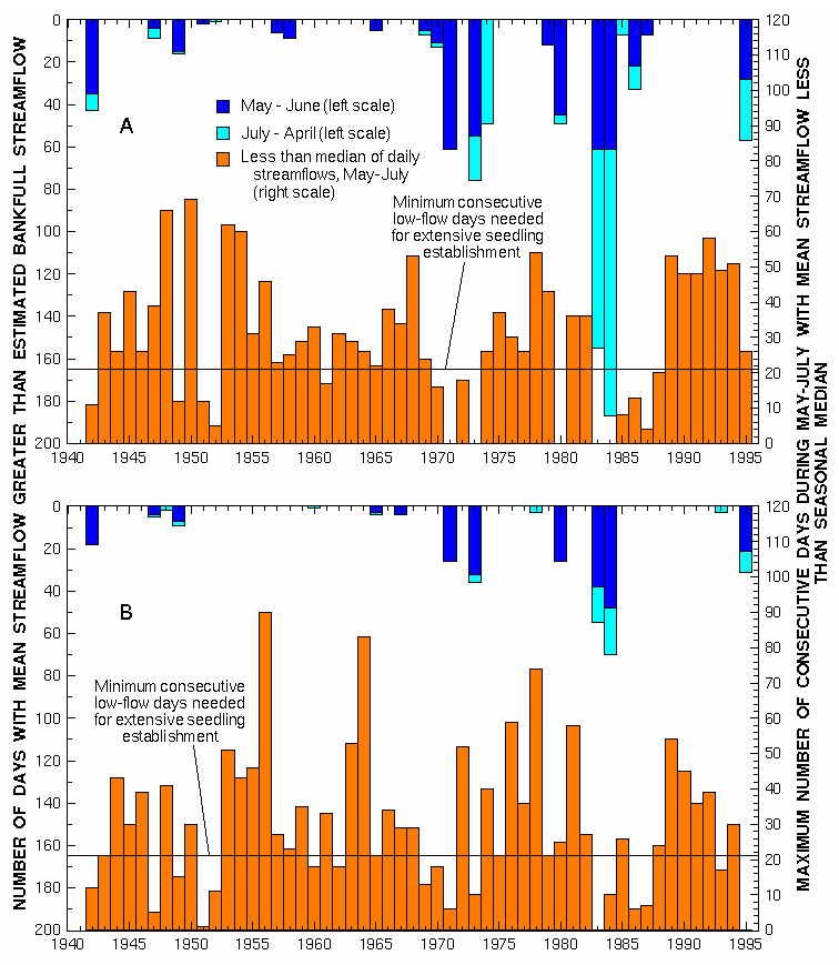
Figure 2 -- Occurrence by calendar year of daily mean streamflow greater than estimated bankfull streamflow and of May-July daily mean streamflow less than seasonal median streamflow, 1942-95, for (A) Platte River at Brady (total flow) and (B) Platte River near Grand Island.
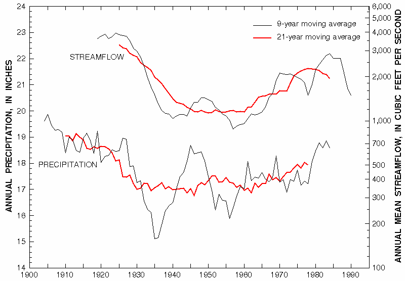
Figure 3 -- Moving-average smoothed annual precipitation in seven climatic divisions encompassing the drainage basin, and moving-average smoothed annual mean streamflow, of the Platte River near Overton, Nebr. (Precipitation data from National Climatic Data Center, 1994)
As was done for the high-flow data summarized in figure 2, the low-flow record for 1942-68 was compared with the 1969-95 record. At Grand Island, the decreased occurrence between the two periods was from 20 to 17 years, not a significant change (p(X²>1.205)=0.27). At Brady, 22 of the 27 former years had at least 21 consecutive days with below-seasonal median streamflow, but only 16 such years occurred in the latter period. The frequency of years with low-flow conditions favorable for expansion of woody vegetation into active-channel areas decreased near Brady (p(X²>7.425)=0.0064) during 1969-95 as compared with 1942-68. This change could be the result of both climatic change (figure 3) and minimum-streamflow management.
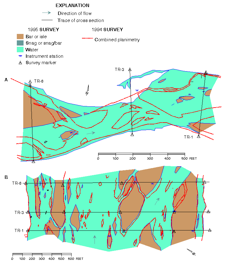
Figure 4 -- Surveyed planimetry of study reaches in 1994 and 1995 for
Platte River near (A) Brady and (B) Grand Island, Nebr.
Comparison of the reaches illustrates mostly expected differences in channel characteristics between upstream and downstream locations. However, near Grand Island, bankfull mean depth (2.0 ft) is less than that at Brady (3.2 ft). Depth, width, WD, and Qbf typically increase downstream in proportion to drainage area (Leopold, 1994; Osterkamp and others, 1983); however, for channels having large WD and no downstream increase in silt-clay content in bed and banks, width increases rapidly whereas depth changes slightly (Osterkamp and others, 1983). The area drained by the Platte River at Grand Island is about 5 percent larger than at Brady, but estimated Qbf is more than twice that for Brady. Because of substantial diversion of flow around the Brady reach by the Tri-County Supply Canal, the width and estimated Qbf there are atypically low relative to Grand Island. Bankfull width and average WDbf near Grand Island are nearly five times greater than near Brady. Also, the Is value near Grand Island (11.6) was more than three times that near Brady (3.19); the differences in Is and bankfull mean depth both reflect the contrast between a highly braided reach and a slightly braided, meandering reach.
Historical data for the Platte River, compiled from the original U.S. Government plats of Nebraska (circa 1865-70), indicate that the total combined width of all channels may have exceeded 3,800 ft at Brady (Williams, 1978); however, Johnson (1994) points out evidence that many small islands were omitted from the original survey and suggests estimates of pre-1880 width be reduced by 10 percent. Study of a 1989 aerial photograph of the Brady channels indicates that most of the historical width was contained in the south channel. The aerial photograph and recent channel measurements (U.S. Geological Survey, unpublished field data, 1991) both indicate that at least 90 percent of the present active-channel width is in the north channel. Thus, the present total width is about 12 percent of the historical width. Ratios of present-to-historical width of 10 to 15 percent have been published for other cross sections in the North Platte to Cozad reach (Williams, 1978; Eschner and others, 1983; Johnson, 1994). Channel width at Grand Island was shown on the 1898-edition 30-minute USGS topographic map as 3,600 ft (Eschner and others, 1983). The 1995 width of the active channel near Grand Island is 44 percent of the 1898 width.
Water-surface slope near Brady was 0.00114 ft/ft, or 6.02 ft/mi, in the 1995 survey. This result is consistent with a slope of 6.07 ft/mi measured in 1993. Near Grand Island, the water-surface slope was 0.00129 ft/ft, or 6.8 ft/mi. The 1993 survey produced a similar result (0.00131 ft/ft, or 6.9 ft/mi). Channel slope typically decreases in the downstream direction along a river, so the measured channel slopes (13 percent steeper in the downstream reach) indicate an atypical situation. Flattening of channel slopes is one possible geomorphic response to upstream construction of dams (Williams and Wolman, 1984) that may have affected the Brady reach but has not yet affected the Grand Island reach.
Channel degradation (lowering) downstream from Kingsley Dam also was
suggested by the cross-section results from the Brady reach. Data from
each surveyed cross-section were used to plot profile comparisons,
such as those shown in figure 5 for the upstream cross section (TR-6)
in the Brady reach. The estimated bankfull stage is 1.6 ft
below the height of the left terrace bank; this channel lowering
agrees with the degradation reported for the 1940-77 period (Williams,
1978). Figure 5 also demonstrates some of the effects of bankfull
streamflows, such as the erosion of a sand bar centered at 290 ft from
left bank, and the building and extending of a bar surface at bankfull
stage (centered at 220 ft from left bank). The comparison of annual
cross-channel profiles shows that greater change occurred between the
1994 and 1995 surveys than between the 1993 and 1994 surveys,
indicating the effect of the unusually high flows during May through
July 1995.
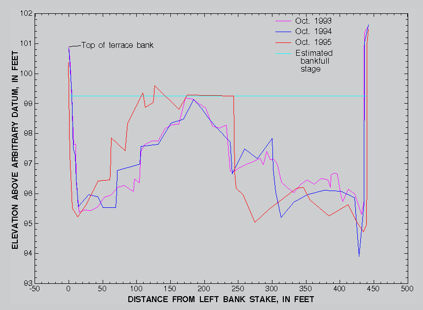
Figure 5 -- Profiles of surveyed cross section TR-6 of Platte River near Brady, Nebr., October 1993-95.
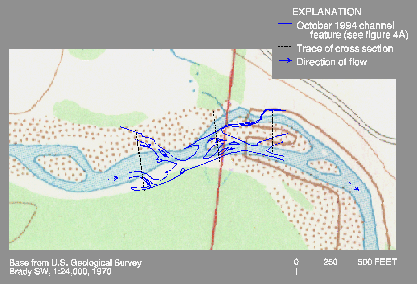
Figure 6 -- Georeferenced planimetry surveyed October 1994 as shown on a 1970 topographic quadrangle, Platte River near Brady, Nebr.
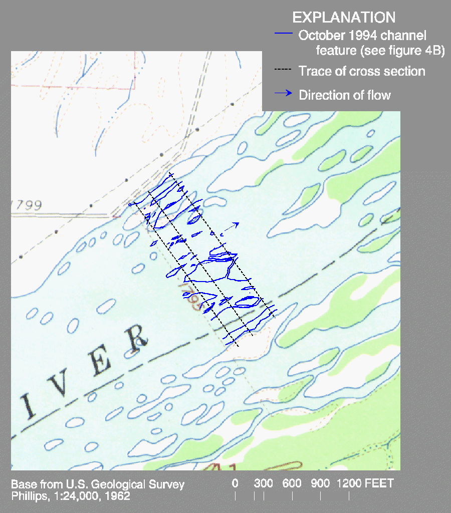
Figure 7 -- Georeferenced planimetry surveyed October 1994 as shown on a 1962 topographic quadrangle, Platte River near Grand Island, Nebr.
Of the Platte River reaches, only Grand Island was sampled for fish community structure following the flood of 1995. This sample was more similar to the 1994 sample from Grand Island than samples from the Brady reach or the Grand Island reach in 1993. Although the fish community structure was similar at Grand Island between 1994 and 1995, there were only 16 species present in 1995 versus 21 in 1994. Species abundance also was noticeably lower in 1995.
Whereas the 1995 peak flow reworked instream habitats to a small degree, the reestablishment of an assemblage of species similar to that of 50 years prior requires a species pool to draw upon for colonists. For many aquatic species, flood plains may be critical habitats during certain life stages. Regulated streamflow regimes that do not inundate flood plains with a frequency similar to unregulated conditions result in loss of access to flood plains. Because the loss of broad shallow channels and access to flood plains is a regional problem, the species pool probably is lacking for rapid recolonization. Fish assemblages have been demonstrated to be fairly persistent (Ross and others, 1985) despite occasional disturbances, and without a long-term modification to instream habitats, future assemblages probably will be similar to those sampled during 1993-95. Continued scouring of the vegetated islands would, however, recreate the habitat template favorable for the recolonization of native species.
Bowman, David, and Carlson, Dave, 1994, Pulse flow requirements for the central Platte River: Grand Island, Nebr., U.S. Fish and Wildlife Service, 11 p.
Currier, P.J., 1995, Woody vegetation expansion and continuing declines in open channel habitat on the Platte River in Nebraska: Grand Island, Nebr., Platte River Whooping Crane Maintenance Trust, 21 p.
Emmett, W.W., 1975, The channels and waters of the upper Salmon River area, Idaho: U.S. Geological Survey Professional Paper 870-A, 116 p.
Environmental Systems Research Institute, 1992, Understanding GIS--The Arc/Info method: Redlands, Calif., Environmental Systems Research Institute, 450 p.
Eschner, T.R., Hadley, R.F., and Crowley, K.D., 1983, Hydrologic and morphologic changes in channels of the Platte River Basin in Colorado, Wyoming, and Nebraska--A historical perspective: U.S. Geological Survey Professional Paper 1277-A, 39 p.
Frenzel, S.A., and Swanson, R.B., in press, Relations of fish community composition to environmental variables in central Nebraska streams: Environmental Management.
Hirschboeck, K.K., 1987, Catastrophic flooding and atmospheric circulation anomalies, in Mayer, Larry, and Nash, David, eds., Catastrophic flooding: Boston, Allen and Unwin, p. 23-56.
Jenkins, Allan, 1993, Introduction, in Jenkins, Allan, George, S.K., and Barrett, Elizabeth, eds., The Platte River--An atlas of the big bend region: University of Nebraska at Kearney, p. 1-7.
Johnson, W.C., 1994, Woodland expansion in the Platte River, Nebraska--Patterns and causes: Ecological Monographs, v. 64, no. 1, p. 45-84.
Karlinger, M.R., Eschner, T.R., Hadley, R.F., and Kircher, J.E., 1983, Relation of channel-width maintenance to sediment transport and river morphology--Platte River, south-central Nebraska: U.S. Geological Survey Professional Paper 1277-E, 19 p.
Kircher, J.E., and Karlinger, M.R., 1983, Effects of water development on surface-water hydrology, Platte River Basin in Colorado, Wyoming, and Nebraska upstream from Duncan, Nebraska: U.S. Geological Survey Professional Paper 1277-B, 49 p.
Leopold, L.B., 1994, A view of the river: Cambridge, Mass., Harvard University Press, 298 p.
National Climatic Data Center, 1994, Time bias corrected divisional temperature-precipitation-drought index--Documentation for dataset TD-9640: Asheville, N.C., National Climatic Data Center, 12 p.
Osterkamp, W.R., and Costa, J.E., 1987, Changes accompanying an extraordinary flood on a sand-bed stream, in Mayer, Larry, and Nash, David, eds., Catastrophic flooding: Boston, Allen and Unwin, p. 201-224.
Osterkamp, W.R., Lane, L.J., and Foster, G.R., 1983, An analytical treatment of channel-morphology relations: U.S. Geological Survey Professional Paper 1288, 21 p.
Poff, N.L., and Allan, J.D., 1995, Functional organization of stream fish assemblages in relation to hydrologic variability: Ecology, v. 76, p. 606-627.
Resh, V.H., Brown, A.V., Covich, A.P., Gurtz, M.E., Li, H.W., Minshall, G.W., Reice, S.R., Sheldon, A.L., Wallace, J.B., and Wissmar, Robert, 1988, The role of disturbance in stream ecology: Journal of the North American Benthological Society, v. 7, p. 433-455.
Ross, S.T., Matthews, W.J., and Echelle, A.A., 1985, Persistence of stream fish assemblages--Effects of environmental change: The American Naturalist, v. 126, p. 24-40.
Schlosser, I.J., 1982, Fish community structure and function along two habitat gradients in a headwater stream: Ecological Monographs, v. 52, p. 395-414.
Southwood, T.R.E., 1977, Habitat, the template for ecological strategies?: Journal of Animal Ecology, v. 46, p. 337-365.
Tabor, V.M., 1993, Declining fishes characteristic of the Central Great Plains: Manhattan, Kans., U.S. Fish and Wildlife Service, November 23, 1993, 11 p.
Williams, G.P., 1978, The case of the shrinking channels--the North Platte and Platte Rivers in Nebraska: U.S. Geological Survey Circular 781, 48 p.
Williams, G.P., and Wolman, M.G., 1984, Downstream effects of dams on alluvial rivers: U.S. Geological Survey Professional Paper 1286, 83 p.
Name:           Ronald B. Zelt
Title:          Hydrologist
Organization:   U.S. Geological Survey
Mail address:   2617 E. Lincolnway
                Cheyenne, Wyoming 82001
Country:        U.S.
Telephone:      (307) 778-2931 ex.2712
E-mail:         [email protected]